
Silk Road map: the main cities from Xi'an to Istanbul
The Silk Road was not one road but a web of caravan routes linking China to the Mediterranean. Here are its main cities from east to west: where each one is today, and what made it matter.
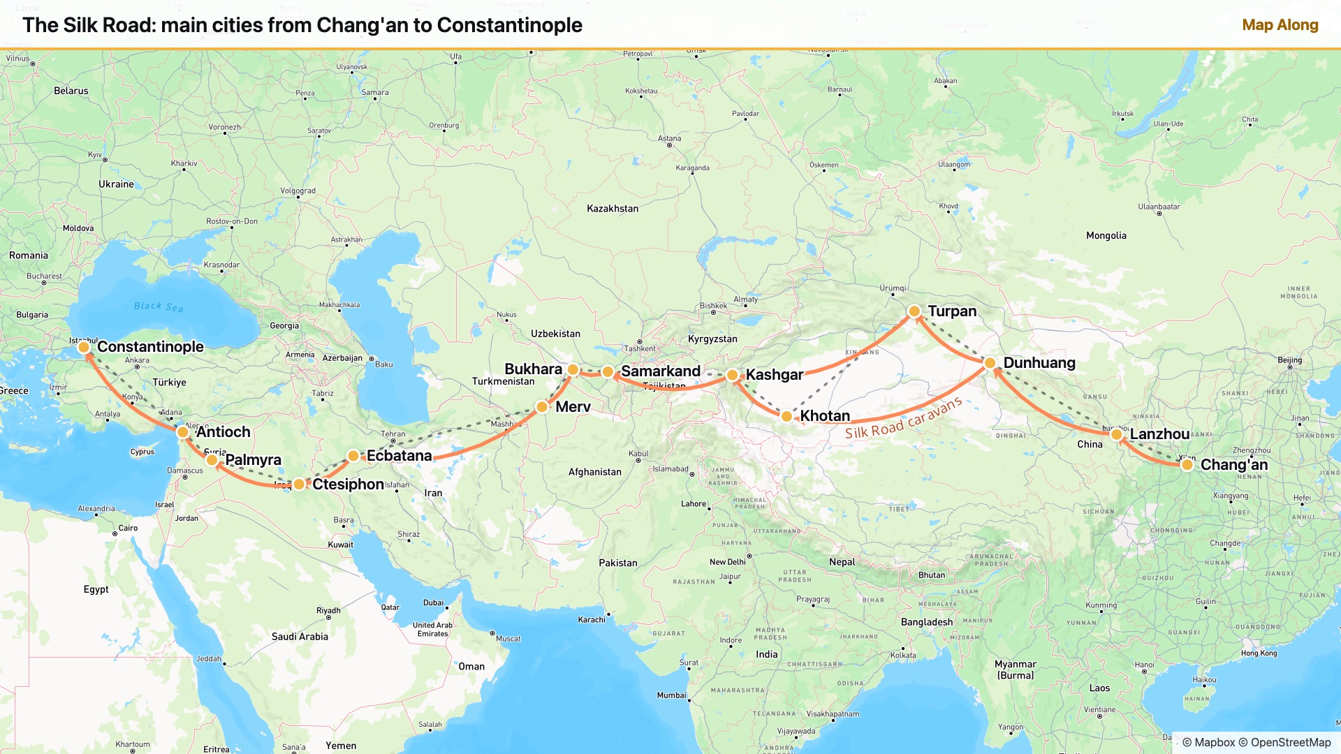
Made with Map Along, a Chrome extension that pins every place a YouTube video mentions as you watch. Open any Silk Road video and you get a map like this one, synced to the narration. Add to Chrome
Every city, from Chang'an to Constantinople
The order runs east to west, the way silk travelled. After Dunhuang the route splits around the Taklamakan Desert and meets again at Kashgar.
Chang'an
Today: Xi'an, China
The capital of Han and Tang China and the eastern start of the road. Around 138 BC the envoy Zhang Qian left from here for Central Asia, and his reports opened the way west.
Lanzhou
Today: Lanzhou, China
Where caravans crossed the Yellow River and entered the Hexi Corridor, a narrow strip of oases between mountains and desert.
Dunhuang
Today: Dunhuang, China
China's last outpost before the desert, guarded by the Jade Gate. Travellers left prayers and paintings in the Mogao Caves, and a sealed library of tens of thousands of manuscripts was found there in 1900.
Turpan
Today: Turpan, China · northern route
An oasis in one of the lowest, hottest basins on Earth, kept green by underground irrigation channels called karez. The northern route ran along the foot of the Tian Shan from here.
Khotan
Today: Hotan, China · southern route
The jade city of the southern route. Legend says a Chinese princess smuggled silkworm eggs here in her headdress, and Khotan began making its own silk.
Kashgar
Today: Kashgar, China
Where the northern and southern routes met again, below the Pamir mountains. Its Sunday market still draws traders from across Central Asia.
Samarkand
Today: Samarkand, Uzbekistan
Home of the Sogdians, the great middlemen of the road, who ran caravans from Persia to China. By the 8th century Samarkand was making paper, and the craft spread west from here.
Bukhara
Today: Bukhara, Uzbekistan
A trading oasis that became one of the great centres of Islamic learning. Its old town, with its covered bazaars, is still standing.
Merv
Today: near Mary, Turkmenistan
A huge oasis city on the edge of the Karakum Desert, for a time one of the largest cities in the world. Its ruins cover several square kilometres.
Ecbatana
Today: Hamadan, Iran
An old royal city on the road across the Iranian plateau. Parthian Persia controlled this stretch and grew rich charging middlemen's prices for silk bound for Rome.
Ctesiphon
Today: near Baghdad, Iraq
Capital of the Parthian and later Sasanian Persian empires, on the Tigris. Its great brick arch, the Taq Kasra, still stands.
Palmyra
Today: Tadmur, Syria
A caravan city in the Syrian desert whose merchants ran camel trains between the Euphrates and the coast. Its colonnaded streets are among the best-known ruins of the ancient world.
Antioch
Today: Antakya, Turkey
One of the largest cities of the Roman East and a gateway to the Mediterranean, where eastern goods were loaded for Rome.
Constantinople
Today: Istanbul, Turkey
The western end of the road after Rome's capital moved east. Around 552 two monks smuggled silkworm eggs here in hollow canes, and the Byzantine Empire started its own silk industry.
How accurate is this map?
Every city on it is real, and these are their real locations. The lines are simplified: the Silk Road was a shifting network of routes, with branches south into India through Taxila, north across the steppe and by sea through the Indian Ocean. The cities also mattered at different times. Palmyra was at its height in the 2nd and 3rd centuries, while Constantinople only became the western end after AD 330.
Few people ever travelled the whole route. Silk, paper, spices, horses, glass and ideas, including Buddhism, moved in short steps, each city trading with its neighbours.
Watch a Silk Road video with this map
Map Along builds a map like this from any video as you watch it, pinning each place at the moment the narrator says it. Try it on one of these:
 The Silk Road and Ancient Trade: Crash Course World History #9CrashCourse · 6.2M views
The classroom favourite, in ten minutes.
 The Silk Road: Connecting the ancient world through tradeTED-Ed · 4.4M views
Follow one bolt of silk from China to Rome.
 How did The Silk Road Actually Work?Knowledgia · 3.2M views
Caravans, middlemen and who got rich.
 History of Silk Road: How ancient China opened trade with the WestHistory on Maps · 277K views
The story told on an animated map.
For teachers
Download the full-size map; it is 1920×1080 and fits a 16:9 slide. After a video, students can take a quiz on it or try to place each city on a blank map. To make a map like this from any other video, see maps for your slides.
Questions
How long was the Silk Road?
About 6,400 km (4,000 miles) from Chang'an to the Mediterranean by the main overland routes. Almost no one travelled the whole way: goods passed from merchant to merchant, city to city.
Why is it called the Silk Road?
The name is modern. The German geographer Ferdinand von Richthofen coined it in 1877, after the Chinese silk that Rome prized. People at the time had no single name for the routes.
When was the Silk Road used?
From around 130 BC, when Han China opened contact with Central Asia, until the 1400s, when sea routes took over most long-distance trade. It was busiest under the Han and Tang dynasties and again under the Mongols.
Can I use this map in class?
Yes. Download the full-size image and use it in lessons, slides and handouts. Keep the Mapbox and OpenStreetMap credit in the corner.
Every place in a video, on the map
Map Along works on any YouTube video: history, travel, geography, documentaries. New accounts get 3 videos free. See pricing.